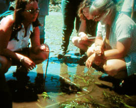
Coastal communities have been instrumental in raising awareness of the importance of eelgrass habitat. In recent years the majority of our work has been focused on the Salish Sea. Many member groups have incorporated bull kelp monitoring and forage fish spawning surveys into their nearshore conservation programs. Recent changes to the Canadian Fisheries Act have eroded eelgrass protection, making the work of SCWG members even more critical. Below are samples of ongoing eelgrass monitoring programs.
Member conservation programs:
Mayne Island Conservancy Society
Located in the southern Gulf Islands, Mayne has been the site of ongoing nearshore monitoring of eelgrass and bull kelp since 2009, and a baseline forage fish spawning habitat inventory. In 2013, the Conservancy completed an inventory of natural and anthropogenic features of Mayne Island’s shorelines that was shared with the Islands Trust to be used as a land use planning tool for nearshore and shoreline conservation. Also, check out the Conservancy’s new video featuring their eelgrass monitoring work.
Mayne Island Atlas of Shorelines 2013
Video: https://youtu.be/qBRDZvAUJEI
SeaChange Marine Conservation Society
Since 2001, SeaChange has been mapping, monitoring and restoring nearshore habitats in Saanich Inlet and along Saanich Peninsula near Victoria, BC. SeaChange initiated the BC wide network of eelgrass stewards in 2002 and since then has supported local and regional eelgrass conservation efforts. Locally, SeaChange works to provide municipalities with land use decision making tools that preserve nearshore and shoreline ecology (Saanich Inlet and Peninsula Atlas of Shorelines).
Saanich Inlet and Peninsula Atlas of Shorelines 2010
Salish Sea Nearshore Conservation Project 2013-2015
Sunshine Coast Eelgrass Monitoring Program
Dianne Sanford has been mapping eelgrass on the Sunshine Coast since 2001.
Town of Gibsons Eelgrass Mapping Project
Government conservation programs:
Islands Trust Fund’s Nearshore Eelgrass Mapping Program
Completed in 2014, mapping program covered the southern Gulf Islands, composed of 13 major islands and more than 450 smaller islands covering approximately 5200 square kilometres of land and water. Maps are being used by island Trustees to protect eelgrass from impacts such as docks and shoreline development.
See Report: Nearshore Eelgrass Mapping Program
Gulf Islands National Park Reserve
Since 2009, Parks Canada has been monitoring eelgrass meadows to detect trends and changes in fish communities and environmental factors that influence eelgrass growth and distribution, including boating and anchoring activity.
Eelgrass monitoring report 2014
Other conservation initiatives:
Marine Conservation Area in the Southern Strait of Georgia
In 2003, Parks Canada and the provincial government began working to establish the Southern Strait of Georgia National Marine Conservation Area. The Canadian Parks and Wilderness Society is campaigning to make this marine protected area a reality. Eelgrass mapping from the SCWG and other sources have recently been used by CPAWS to perform an analysis of ecosystem value in the area.